There's No Nookie Like Chinookie
There's No Nookie Like Chinookie
By Dennis Dobson
In the Tillamook Bay area, on Oregon's justly famous north coast, there are no truer words of wisdom than those displayed on the familiar bumper sticker: "There's No Nookie Like Chinookie". These words take on a very special meaning when spoken of late season chinook.
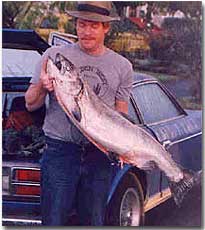 My cousin Steve, an accomplished professional magician, with a 51-pound Wilson River late run chinook hen. Sometimes the hand is not quicker than the eye.
While chinook salmon are available in Oregon from the Columbia River in the north to as far south as the Rogue River drainage as early as July and August, October and November are considered primetime as anglers from around the world congregate in Tillamook each fall to chase these chromed silver monsters. Justly considered the king of North American gamefish, chinook - or "'nooks" - tempt anglers of every stripe and persuasion. Known for the ferocity of their fight, as well as their delectable meat, it's no wonder they're so sought after. Tillamook Bay acts as a natural collection basin for the five premier salmon, sea-run trout and steelhead natal streams that empty into it. Fed by the Miami and Kilchis rivers in the north to the world famous Trask and Wilson rivers and the lesser known Tillamook river at the south end of the bay, each watershed supports varied runs of spring chinook, coho and chum salmon, winter and summer runs of steelhead and sea-run cutthroat trout in addition to the world-famous fall chinook fishery. By the first rains of October chinook have spread throughout both the bay and the tidewater sections of each of these five rivers. With the next heavy rain these fish move upstream into freshwater while fresh chinook move into the bay and tidewater from the Pacific Ocean. This cycle will continue throughout the fall and early winter, progressing with each onlaught of rain and high water, until chinook season ends on December 31st. Even then it isn't uncommon to still be hooking bright chinook well into January's steelhead fishing. Once up river, into freshwater, back-bouncing cured salmon eggs or sand shrimp, drift fishing - either with or without bait - running bait under a bobber and back-trolling plugs or a diver and bait combination are the preferred techniques for consistently taking chinook . And, for those few die-hards, large, gaudy flies tossed with a ten, eleven or twelve weight fly rods and a fast-sink tip line will also account for more than a few filled tags. As popular and heavily fished as the weeks between the end of September and the middle of November may be in Tillamook many locals and most visitors completely overlook the year's best run of trophy fish. Each year, once the primary fall run of chinook starts to taper off in mid to late-November, area rivers host a late run of fish. Bracketed by Thanksgiving and New Years - and a small run in terms of numbers - this 'Holiday Run' features the seasons' largest fish. During the main run in October and November, when chinook average twentyfive pounds and run to about forty pounds, and fifteen to twenty thousand chinook choke local bays and rivers on any given day, thousands of anglers visit the area in hopes of tangling with just one of these hefty silver bullets. By Thanksgiving, when the weather has turned cold and wet and the vast majority of fair weather anglers are home watching football games and preparing for the holidays, a small group of dedicated cognezenti and local fishing guides break out the heavy gear and start playing with the "Hawgs". During this Holiday Run the average chinook will top thirty pounds. A large one will weigh in excess of fifty pounds and every year at least a few of my clients will bag fish weighing more that sixty pounds. That's right, I said more than sixty, that's six-zero, pounds. Each. Three Tillamook area rivers, the Trask and Wilson, and most particularly the Kilchis, offer late season anglers the chance to bag a wall-hanger. A true trophy chinook in the fifty pound or better range. Here then is a basic primer for the bank angler and driftboater looking to fish one of these three premier late run rivers. 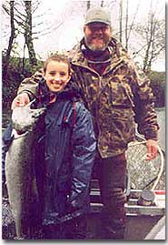 Young Christopher Marshall with a very respectable Trask River 40-pounder.
The Wilson River
With the possible exception of central Oregon's Deschutes River and the south coast's Rogue River, more has probably been written over the years about the Wilson than any other river in Oregon. Justifiably famous, as well as easy to access, the Wilson hosts a plentiful run of both primetime and late season fall chinook. Followed by Highway 6 west of Portland from where the river drops out of the Coast Mountain Range gorge at about rivermile 30, west until just four miles before reaching Tillamook, the Wilson is a perennial favorite of both salmon and steelhead anglers. Easily accessible from the highway for most of this length it has become a traditional hot spot for bank anglers as well as driftboaters. For bank anglers the scenario is fairly simple: anywhere along Highway 6 you can park safely and do not see "No Trespassing" signs you can pull over and walk to the river. Ranging, especially in its upper reaches, from classic 'pocket water' to deep, steep-sided canyon pools, the Wilson offers anglers a wide variety of water types and environments to fish. All of the classic salmon fishing techniques will work somewhere along this stretch. From jig or bait and bobber combinations in the deeper pools to drift fishing corkies and yarn or fly fishing the faster runs and riffles, from spinners to spoons, virtually any angler can find water that will meet both their needs and expectations. For bank anglers the best stretch runs from about mile 25 to Mill Creek, behind the Guide Shop. Below Mill Creek the property is all privately owned and access is, by and large, severely restricted. The major exception to this rule is Josi's Hole where you can pay to play and a few isolated spots clearly marked along the highway. 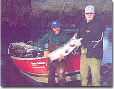 It's his 16th birthday and his first chinook. Chris Zelenka (right) with a very nice 54-pound Kilchis River chinook buck.
Drift boat enthusiasts face another situation, however. While there are three main boat put-ins, and a fourth that is only occasionally usable, I hesitate to characterize them as ramps since they more closely resemble slides, your choice as to which you use should be dictated by skill rather than convenience. At the higher end of the river, near the bridge at mile thirteen, there is a very rugged slide. I do not recommend that anyone other than a truly proficient oarsman try this run. The water between mile thirteen and the next takeout is boulder-strewn, narrow and very fast. And, while it is by no means the trickiest water in the area to navigate safely, it does require a high degree of competency to safely negotiate. There is a boat put-in between Alice's Restaurant (about mile 8) and mile thirteen - approximately a mile upriver from the restaurant near mile 9 - but it can be both tricky to use and misses a lot of good water. This particular ramp is poorly designed and requires nearly perfect water conditions to use safely. And we very rarely get perfect water conditions. The next popular run downstream, from mile eight to Mill Creek, is noticeably easier to drift. Hidden behind a small hill on the south side of the highway directly opposite a tree farm and just one-quarter mile west of Alice's Restaurant - between Siskeyville and Deadman Creek - the put-in at mile eight is relatively well maintained, easy and safe to use and presents a relatively short drift of about two-and-one-half miles to Mill Creek. While noted for its steelhead-style pocket water, this stretch does hold salmon as they work their way upstream to spawning beds in Cedar and Jordan creeks. The drift from Mill Creek, on the gravel bar behind the Guide Shop on Highway 6, to Sollie Smith Bridge at the head of tidewater is by far the most popular and productive drift on the river. Easy to use, under most circumstances, this is an easy slide into the river. This drift also encompasses the best salmon holding water on the entire river. The river begins to widen out below Mill Creek and offers boat anglers a wide variety of fishing conditions. From deep, slower pools like Josi's Hole and the Piling Hole to short, fast, relatively deep holding water on the downstream end of islands and clearly defined slots, this drift allows anglers to mix and match their techniques. Back-trolled plugs or divers and bait and back-bouncing generally produce best in the slots while bobber fishing and drift fishing and even tossing spoons and spinners will take fish out of the deep pools. This drift is also, at less than four miles in length, just about perfect for a full-day drift; short enough to allow you to work each stretch of water thoroughly and long enough to provide some variety and a little room for boats to spread out. There is another pay-access launch and bank fishing site at Donaldson's - turn north onto Donaldson Lane about ½ mile west of the river canyon - but it was completely re-worked by the flood of 1996. Although the areas both below and above Donaldson will hold fish, the run right in front of this stretch of river shallowed so much, due to gravel fill from the flood, that it rarely holds fish. And, while you can put a boat in there if the gravel bar is solid enough and you are driving a four-wheel drive rig, generally speaking the put-in at Mill Creek is easier to use. 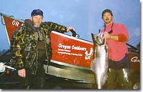 Dennis and Shannon O'brien (right) with Shannon's largest fish ever - a gorgeous 58-pound Kilchis River chinook hen.
Finding The Wilson River: Drive west out of Portland on the Sunset Highway (Hwy 26) following the signs to "Ocean Beaches". Turn south, again towards "Ocean Beaches/Tillamook", on Highway 6 near North Plains. Highway 6 will take you all the way into Tillamook. The best bank fishing begins at about mile post 25 and continues all the way to just four miles before you get to Tillamook. To find Sollie Smith Bridge, stay on Highway 6 until just a mile before Tillamook. Turn right (north) on Tillamook River Road at the flashing yellow light. Follow the road until you see the bridge and parking lot on your right. The Trask River
The Trask is blessed with both a good run of fish and fairly easy access for bank anglers along most of its length. From Trask River Park (maintained by Tillamook County), at the confluence of the north and south forks of the river, downstream to about Dam Hole the river is accessible at virtually every bend and turn-out. Again, as long as you can park safely off the road and don't see any signs forbidding trespass, most of this stretch can be accessed from the bank. From Dam Hole downstream to Highway 101 there are only two spots accessible to the public for bank angling. One is the stretch just above and below Loren's Drift, off of Chance Road, and the other is the boat take-out just 1/8th of a mile above Highway 101. For driftboaters the Trask represents a unique combination of very good fishing water, most of it easily navigated, interspersed with one of the most dangerous pieces of river water on the northern coast. The boat slide at Stone's Camp, on the Kansas Creek Cutoff, can be tricky to negotiate. Depending upon river and weather conditions it can either work easily or not at all. It's single major drawback however, is its proximity to a series of very dangerous rapids, rocks and in-stream navigation dangers that begins about a mile downstreram, just below Dam Hole. If, and I emphasize 'IF' you choose to use the slide at Stone's Camp, DO NOT miss the take out between Samson Creek and Burton Creek as it is your last chance to avoid this very nasty stretch of water. I am very serious about this: every few years this piece of river kills some unsuspecting rafter, driftboater or a kid in an inner tube. There are two more boat slides between Dam Hole and Loren's Drift, the most popular put-in on the river. The launch at Panther Creek can, again depending upon river levels and weather conditions, either be easy or difficult. The drift downstream to Loren's is, however, one of the nicest and most productive on the river. The next launch downstream is at Hanenkrat's, just below the fish hatchery and is accessed via Chance Road. A nominal fee is usually charged to use this ramp but it is well maintained and once again, the drift down to Loren's is well worth the two or three dollar fee. Without a doubt the most popular drift on the river begins at Loren's Drift off of Chance Road and ends at the Highway 101 take-out. This drift, just under four miles in length, encompasses most of the truly good salmon water on the entire river. With a nice combination of deep holes, narrow slots and faster riffled water it presents anglers with a delicious mix of fishing opportunities. It also sees the most traffic, on an average day, of any other drift on the river. Finding The Trask River: Although you can get to the middle Trask without going through Tillamook, it is easier for first-timers to stay on Highway 6 all the way into Tillamook. Turn south on Highway 101 and follow it to the flashing yellow light at Long Prairie Road about a mile-and-a-half south of Tillamook (you can't miss this turn, even in the dark: there is a big jet fighter on a metal pole on your left advertising the Air Museum- just turn left at the jet). Turn left onto Long Prairie Road. The Highway 101 takeout is just 1/8 of a mile up the road, on your left. There is a boat ramp sign opposite the driveway on the right hand shoulder of Long Prairie Road. To access Lorens' Drift, follow Long Prairie Road for about two miles. Take a right on Chance Road, just past a wide, sharp left-hand turn in the road. There will be a fish hatchery sign on the left shoulder of Long Prairie Road opposite the turn onto Chance Road. Follow Chance Road for about 2-1/2 miles. There are two very slow, sharp bends in the road. The first, to the left and the second to the right. About a half-mile after the second turn there is a road, a barn and a pasture on the left. There will be a sign stating the boat ramp is on private property but is maintained by the county. Turn left onto this road. Although just a mud slide, this access is easily spotted after turning off of Chance Road. To find the county park, stay on Long Prairie Road past the turn off to Chance Road. One-half mile past Chance road turn right onto Trask River Road, immediately past Johnson's Bridge. Follow Trask River Road for several miles to the county park. The Kilchis River
Arguably one of the two or three prettiest streams on the north coast, the Kilchis is a prime late season chinook fishery. Headwatering less than twenty miles from the ocean it is also one of the shortest rivers on the coast. Best known as a fine chum salmon and primetime chinook stream, the "K" also consistently produces some of the largest fish taken in the area every season. Bad news, however, for bank anglers. There are just four spots on the entire river that bank anglers can access. The county park, at roads' end on the north side of the river about five miles upstream from Highway 101, offers the most access. With almost ¾ of a mile of access downstream from the boat slide, including two of the deepest pools on the river, the park offers bank anglers the most variety. Although you can hike upstream from the park, on the park side of the river, the trail quickly climbs into a series of tall, steep canyon walls that severely limit any angler's access to the river. To access the second public stretch, follow Kilchis River Road to the logging bridge less than two miles from Highway 101. Turn south across the bridge and follow the road for about a mile. This will put you at the gravel bar maintained by Bay City. There is about a quarter of a mile of access along the south bank here. You can also access one more spot on the south bank by following the road just over a mile further. There is a small creek and limited picnic/camping area here. There is one good salmon run just where the creek enters the main river but fishing is very limited. Driftboaters have it better on the Kilchis. There are three ramps or slides along its length with each allowing access to noticeably different types of holding water. At the upstream end there is a boat slide at the county park that provides access to about two miles of river between there and the logging Bridge. With several deep pools and lots of swift riffles, deep slots and undercut banks, this stretch offers anglers a nice variety of water. This stretch is noted not only for its chinook fishing but is also prime for both chum salmon and winter steelhead. Downstream from the park is a boat slide and beach at the logging bridge, just across the river from Mape's Creek. This landing is also a major congregation site for bank anglers as it offers the only other public access on the river and features a very nice hole with runs just below and above it. Generally kept in good shape, this boat launch has a concrete ramp and a modest beach where boats can be parked while you get your gear ready to go. With a run of just under two-and-a-half miles down to Park's Landing - the last ramp on the river - this stretch offers a heavy concentration of good chinook holding water and, as a result, tends to see the most angling pressure. Although many, if not most, boaters tend to start fishing about two hundred yards downstream from the ramp at the logging bridge, opposite the gravel company, there is one slot just below the bridge that shouldn't be overlooked. Especially when pressure is heavy fish will move up into this stretch from the gravel pit hole just below it. Situated just about even with the upstream end of the gravel operation, this run is marked by a series of boulders breaking the rivers' surface along the right hand or northern side of the river. While back-trolling plugs or diver and bait combinations through this short run will pick up the occasional fish, I prefer to anchor just above the first rock and back-bounce bait down the entire length of the run. A short run, at just about 25 yards, it nonetheless is deeper than it first appears and has three nice holding pockets, each behind a big boulder poking out of the water, spaced down its length. Although there are a number of popular salmon holes along this drift, including first and second bridges (counted as they descend downriver from the logging bridge) and Elbow Hole ( ¼ mile below second bridge, where the river takes a full and abrupt ninety degree turn to the left), by far the most popular and productive is Pipeline. Located less than a mile from the takeout at Park's Landing, Pipeline is easily identified by the 12-inch diameter irrigation pipe that spans the river just under the surface of the river. Anchoring on the left side of the river twenty feet above the pipe and letting your boat down on the anchor rope until the bow sits just over the pipe will place you in the best position to back-bounce or drop plugs or divers and bait down into the meat of the hole. 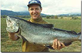 Vince Rosauer and a spectacular Trask River 61-pound chinook.
A note on courtesy here: while this is true of any river it is particularly important on a river as small as the Kilchis. Generally speaking, there is enough room in each hole on the "K" for two boats to anchor side-by-side while allowing enough room on one side or the other for other boats to pass by without floating over the spot you are fishing. If you are the first boat into a hole, please anchor in such a manner that another boat can share the spot with you without making a navigation hazard of themselves. Also, if you are first into a prime hole, offer to share it with each boat that comes by. And, if you are coming into a good hole and see another boat already anchored there, show them the courtesy of asking if you can share it before plopping down your anchor. Most boaters will gladly share the hole, especially if asked nicely. If they say no, ignore them if you choose to. After all, you did ask nicely and it isn't their river. On the other hand, no salmon hole is worth getting shot over. Use common sense, good judgment and some manners. Park's Landing, just 1/8 of a mile above Highway 101 is the last ramp on the river. A concrete ramp with a large parking lot and a chemical toilet it also marks the head of tidewater on the Kilchis. While many folks will put in their power boats at this ramp so they can motor downstream to bobber and plug fish for salmon, most of the time it is used as the takeout for driftboaters coming from upriver. If you choose to put a motorized boat in at this ramp, please bear in mind that the entire river from the ramp downstream to the bay is a no wake, 5 mile per hour section. Finding The Kilchis River
Go north on Highway 101 from Tillamook. Just over the top of the hill, about ¾ of a mile beyond the cheese factory (the largest structure in Tillamook and very hard to miss) turn right on Alderbrook Road. The sign will indicate Idaville and Kilchis County Park. Park's Landing is the first road to the left, less than 1/8 of a mile after the turn and the parking lot there can be easily seen from the road. To get to the logging bridge and the county park, follow Alderbrook Road for about ½ mile. When it splits, follow it to the right. The logging bridge is about a mile further upriver on your right just past the gravel operation and a vividly yellow house (both on your right). Follow the road another 2 miles past the logging bridge to find the county park. The road ends at the park. The boat slide is to the right as you enter the park. Follow the road about 150 yards until you spot several very large Douglas Fir and cedar trees. The ramp is situated between two of these trees. Other Resources:
For river reports and fishing information
Kimmel's Sporting Goods 503-842-4281
Tillamook Bait Company 503-842-5031
The Guide Shop 503-842-3474
Oregon Outdoors Guide Service 503-815-2766
Copyright Dennis Dobson, Oregon Outdoors. Email Dennis at [email protected] or visit his website at http://www.oregonoutdoors.org.
|