Down from the Hills of Habersham, Georgia
Down from the Hills of Habersham, Georgia
By Bill Vanderford
"Out of the hills of Habersham, down through the valleys of Hall, I hurry amain to reach the plain, run the rapid and leap the fall, split at the rock and together again, accept my bed, or narrow or wide, and flee from folly on every side, with a lover's pain to attain the plain, far from the hills of Habersham, far from the valleys of Hall."
 Though I was in my preteens before I ever saw the Peach State's most magnificent river, my Mother taught me that first verse of Sidney Lanier's famous poem, "Song of the Chattahoochee", before I reached my sixth birthday. Since then, however, I have had the pleasure of sampling the potpourri of fabulous fishing opportunities while visually feasting on some of Georgia's finest vistas from the hills north of Helen to Lake Seminole, where the Chattahoochee joins the Flint to become the Apalachicola River prior to pouring its fertile waters into the Gulf of Mexico. With the beginning of trout season this month, some basic knowledge of the upper Chattahoochee River seems to be an appropriate subject.
The first trickle of a stream that biologists consider the extreme headwaters of the Chattahoochee actually begins in Union County. Other small streams like Henson Creek have their beginnings in adjacent Towns County, and much of the trout-rich upper Chattahoochee River is in White County. Therefore, despite the beautiful words, Sidney Lanier left out much of this famous river at the start of his poem.
Though only accessible to the toughest of the trout fishing clan because of the remoteness of the area, the upper Chattahoochee and Henson Creek are still home to some of the last native eastern brook trout in the southeast. Though they seem to be thriving in these creeks that are hidden by undergrowth, they can't stand much fishing pressure.
Farther down, one can catch both stocked and native rainbow trout in Low Gap and Jasus Creeks. Also, Spoilcane Creek runs down from the vicinity of Unicoi Gap alongside Highway 75 north of Robertstown. It can be seen from the highway, and is easy for anyone to fish. Certain sections, however, run through private property, so check before wetting a hook.
Most of the mainstream of the upper Chattahoochee River is in the WMA and can be accessed from Forest Service Road 52. This section has both wild trout and stocked rainbows, browns, and brooks during the season.
From the Highway 75 Alternate Bridge at Robertstown south through the town of Helen, one can now catch stocked trout year-round. This is an especially popular and scenic stretch of the river, and can be extremely busy with canoe or tube traffic at times. Nevertheless, it is a good place for Dad to fish while the wife and kids enjoy the carnival atmosphere and great shopping in the Alpine village of Helen.
Actually catching the small trout from the farthest upper sections of the Chattahoochee and its tiny tributaries is very difficult because of the size of these waters and the undergrowth. Nevertheless, if one is willing to get on your knees at times, and present diminutive, #16 dry or wet flies in almost cane pole-fashion, wild brook and rainbow trout can be caught. Farther down in parts of the WMA, more normal casting is possible, and from Robertstown through the town of Helen, the fishin' is easy for even a novice fly caster.
Fishing is not allowed in the immediate vicinity of the falls and store at historic Nora Mills. Also, the river from below Nora Mills down to the Highway 255 bridge along the White/Habersham County line has poor public access, and private landowners often take offense to trout fishermen or whitewater enthusiasts that come in contact with their property. Therefore, it is not recommended trying to fish this stretch of the Chattahoochee River.
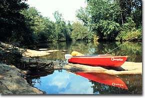
By putting in at the Highway 255 bridge, however, one can float a beautiful section of the Chattahoochee that meanders through long quiet stretches that are only broken by occasional rapids. This section of the river from Highway 255 down to Highway 115 bridge is about five miles long and can be navigated by most any experienced person with a canoe, kayak, rubber raft or float tube.
The only dangerous spot is the Smith Island Rapid, which is about three miles into the float. It is a Class II rapid that is usually run by staying left for the first two ledge series, then moving right for the bottom chute, which empties into a picturesque pool with a grotto-like setting. If the water level is above three feet, the right side of the island is also navigatable, but be sure to maintain a route that is right of center.
 Larger flies, streamers, small spinners or the smallest floating or sinking injured minnow lures are best on this first fishable section of the Chattahoochee below Helen. One can usually catch a few of the small stocked trout, but will occasionally hook a trophy-sized rainbow or brown trout.
Another five mile float is also possible from the Highway 115 bridge downstream to the Highway 384 bridge. This section, however, should not be attempted unless one possesses excellent whitewater skills. The Class II and III rapids during the first mile at Buck Island Shoals, at Three Ledges during the third mile and the tricky falls in the Horseshoe Rapid in the fourth mile are a test for even the most experienced. Nevertheless, if one has the experience, this section of the Chattahoochee River is both scenic and very productive at times, but a little knowledge of these rough spots is helpful.
During the first half mile downstream from the Highway 115 bridge, several small rapids must be navigated followed by a ninety degree left-hand bend, then the river starts to become much steeper in its descent into Buck Island Shoals. This is a very long combination ledge and shoal series that is quite technical at low water and very testy at high water. One should attempt the initial drops on the far left side and remain there until past the first couple of tiny islands, then cut back toward the main channel so that the middle section of this shoal is run right of center. Buck Island will be on the left, and at high water this stretch can be run on the left side of that island.
After clearing Buck Island, a short, calm section is encountered followed by another long, technical section with granite outcrops on the bottom right. If the water is low through here, one has to carefully traverse the far right side and be watchful for a partially submerged rock below the bottom ledge that is known for flipping boats over. When the water is high, all three sections of the Buck Island Shoals become one very long rapid with big waves, fast water, and tricky crosscurrents, and can generally be floated by maintaining a line right of center throughout the section.
As one drifts through a long Class I shoal during the third mile of this float, outcrops of granite on the right side will signal the first drop of the Three Ledges. It should be run to the left of a long, hot dog-shaped rock, then steer back to the right prior to reaching the second ledge, which requires a S-turn through some low, broken ledges during the descent. After this second ledge, maintain a line right of center for a short distance then work back toward the left before attacking the third ledge, which is a three foot drop that extends the width of the river. The best place to go over this small falls is just to the left of the hump in the center. If one ventures too far to the left, then you add to the coloring of "Rainbow Rock", which got its name from the many colors of ABS canoes that have landed on this rock over the years.
The last rapid in this float is the Class III Horseshoe Rapid and may be the toughest for most people to negotiate. Just after entering the fourth mile of this float, one passes through a rocky little Class I shoal followed by a sharp left-hand bend in the river. As the river starts to straighten out here, many people are fooled by the quick drop of the False Horseshoe Rapid, which looks like the entrance to the much tougher rapid waiting about a quarter of a mile farther downriver.
If the water is normal to slightly higher than normal, one can stay more to the left of center and miss the higher, tricky center section of the Horseshoe Rapid. During low water, however, you must start right of center, enter angled to the left, then make a hard right to keep from becoming a statistic on the rocks below.
If you survive Horseshoe Rapid, the river is immediately joined by the Soque River coming in from the left side. From here down to the old iron bridge just north of the Highway 384 Duncan Bridge, which is the best place to take out, is an easy float.
Though extremely exciting to navigate, the section down from Highway 115 contains plenty of choice hiding places for big trout. These fish will hit streamers, spinners, small crankbaits and floating or sinking injured minnow lures.
From the Duncan Bridge all the way to Lula Bridge is another all day float, which has been handled by many novice boaters. A few rough shoals are encountered, but none that are too dangerous for anyone using good common sense.
Trout on this section of the river are few and far between, but when caught, they usually exceed seventeen inches in length. Instead of the trout, however, many fat, acrobatic shoal bass are caught with Swirleybird spinners.
Despite the fact that trout thrive in both the Chattahoochee and Chestatee rivers above Lake Lanier, none seem to venture down into the lake naturally. The few trout that are caught in Lake Lanier today are commercially-raised rainbows that have been released by striper fishermen using them for bait. Until 1987, however, trout were stocked in Lake Lanier annually, but due to changing water conditions, different angling interests, the addition of striped bass, and the cost of the stocking program, it was ended.
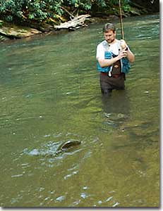
Nevertheless, great trout fishing still exists from below Buford Dam to the mouth of Peachtree Creek in northwest Atlanta. Much of this section of the river maintains a healthy population of resident brown and rainbow trout, but the Georgia DNR also stocks heavily during the trout season from April through October.
Though many of the shallower, shoal sections of this lower part of the Chattahoochee can be waded, float tubes, rubber rafts, or smaller boats seem to be more popular for most trout fishermen. Just pick a section of the river that is not too long, get a buddy to put his car at one end of the float and yours at the other. Check the power generation schedules at Buford Dam and Morgan Falls Dam, if applicable.
Though more dangerous for waders, power generation is accompanied by a rapid rise in the water level and a tremendous increase in the speed of the river's flow. A recording of the intended power generation schedule at Buford Dam is available by calling (770) 945-1466.
Warmer days often find trout anglers traveling to faraway destinations to find better fishing. The beauty that Sidney Lanier described in his poem so long ago, however, is still within easy reach for any angler. The river is always cool and comfortable, and the trout fishing is usually much better than that found in some "greener pastures"!
Excellent additional information is available in the book, "Trout Fishing in North Georgia", which is available from: Jimmy Jacobs, 810 Wendy Hill Road, 22G, Smyrna, GA, 30080. Also helpful is the book, "Secrets to Fishing Lake Lanier", which is available postpaid for $13 from: Fishing Book, PO Box 1222, Lawrenceville, GA, 30046.
|